


คำอธิบายของ WiGLE WiFi Wardriving
Open source network observation, positioning, and display client from the world's largest queryable database of wireless networks. Can be used for site-survey, security analysis, and competition with your friends. Collect networks for personal research or upload to https://wigle.net. WiGLE has been collecting and mapping network data since 2001, and currently has over 350m networks. WiGLE is *not* a list of networks you can use.
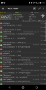
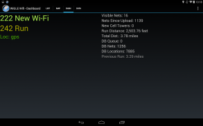
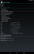
* Uses GPS to estimate locations of observed networks
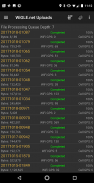
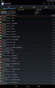
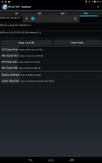
* Observations logged to local database to track your networks found
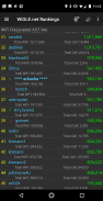
* Upload and compete on the global WiGLE.net leaderboard
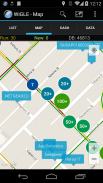
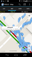
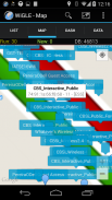
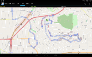
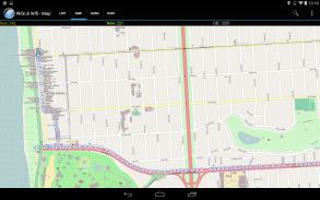
* Real-time map of networks found, with overlays from entire WiGLE dataset
* Free, open source, no ads (pull requestes welcome at https://github.com/wiglenet/wigle-wifi-wardriving )
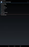
* Export to CSV files on SD card (comma separated values)
* Export to KML files on SD card (to import into Google Maps/Earth)
* Bluetooth GPS support through mock locations
* Audio and Text-to-Speech alerting and "Mute" option to shut off all sound/speech
Current release notes notes: https://github.com/wiglenet/wigle-wifi-wardriving/blob/master/TODO
Feedback and support requests are welcome via email wigle-admin@wigle.net, github, or https://wigle.net/phpbb/viewforum.php?f=13 (registration required).
You can help to improve our language files and translations via pull requests at:
https://github.com/wiglenet/wigle-wifi-wardriving or sending email to wigle-admin@wigle.net
Keep on stumbling!
สังเกตเปิดเครือข่ายแหล่งที่มาของการวางตำแหน่งและลูกค้าการแสดงผลจากฐานข้อมูล queryable ใหญ่ที่สุดในโลกของเครือข่ายไร้สาย สามารถนำมาใช้สำหรับเว็บไซต์สำรวจวิเคราะห์การรักษาความปลอดภัยและการแข่งขันกับเพื่อนของคุณ รวบรวมเครือข่ายสำหรับการวิจัยส่วนบุคคลหรืออัปโหลดไปยัง https://wigle.net WiGLE ได้รับการเก็บรวบรวมและเครือข่ายการทำแผนที่ข้อมูลตั้งแต่ปี 2001 และปัจจุบันมีกว่า 350 เครือข่าย WiGLE คือ * ไม่ * รายการเครือข่ายที่คุณสามารถใช้
* ใช้ GPS ในการประเมินสถานที่ของเครือข่ายสังเกต
* สังเกตบันทึกลงในฐานข้อมูลท้องถิ่นในการติดตามพบว่าเครือข่ายของคุณ
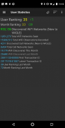
* อัพโหลดและการแข่งขันบนลีดเดอร์บอร์ด WiGLE.net ทั่วโลก
* แผนที่แบบ Real-time ของเครือข่ายพบว่ามีการวางซ้อนจากชุดข้อมูล WiGLE ทั้งหมด
* ฟรี, เปิดแหล่งที่มาไม่มีโฆษณา (requestes ดึงต้อนรับที่ https://github.com/wiglenet/wigle-wifi-wardriving)
* การส่งออกไปยังไฟล์ CSV ใน SD card (จุลภาคคั่น)
* ส่งออกไปยังไฟล์ KML บนการ์ด SD (จะนำเข้าสู่ Google Maps / Earth)
* บลูทู ธ จีพีเอสสนับสนุนผ่านสถานที่จำลอง
* เสียงและ Text-to-Speech การแจ้งเตือนและ "ปิด" เลือกที่จะปิดทุกเสียง / คำพูด
รุ่นปัจจุบันอธิบายคำอธิบาย: https://github.com/wiglenet/wigle-wifi-wardriving/blob/master/TODO
ผลตอบรับและการสนับสนุนการร้องขอจะยินดีผ่านทางอีเมล wigle-admin@wigle.net, GitHub หรือ https://wigle.net/phpbb/viewforum.php?f=13 (ต้องลงทะเบียน)
คุณสามารถช่วยในการปรับปรุงไฟล์ภาษาของเราและคำแปลผ่านทางความต้องการดึงที่:
https://github.com/wiglenet/wigle-wifi-wardriving หรือส่งอีเมลไปยัง wigle-admin@wigle.net
เก็บในสะดุด!
WiGLE WiFi Wardriving--เวอร์ชั่น2.85
(23-02-2024)

WiGLE WiFi Wardriving - ข้อมูล APK
เวอร์ชั่น APK: 2.85แพ็คเกจ: net.wigle.wigleandroidแอปในประเภทเดียวกัน
คุณอาจจะชอบ...


